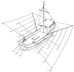
Can you find Barry on the boat? Neither can we.
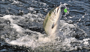
MEDFORD, Ore. (AP) — Enough adult salmon are now finning off the Southern Oregon and Northern California coasts to give Brookings a good chance to repeat as Oregon’s top port for boating chinook. But the ever-changing ocean currents have to do their part. Preseason estimates of chinook and fin-clipped coho salmon in the ocean are high enough that salmon anglers are on the cusp of seeing a summer saltwater salmon season nearly identical to 2014, when Brookings regained its spot as the top chinook port after a one-year hiatus. But El Nino currents forming in the Pacific threaten to disrupt the cold-water patterns needed near shore to draw in the bait fish that in turn draw chinook and coho into the reach of Oregon’s bustling offshore recreation fleet. “The season, of course, depends upon how the ocean sets up,” says Richard Heap, a Brookings angler who represents Oregon anglers in federal salmon-season discussions. “If it does, the fish should be there. Hopefully, we’ll knock the stuffing out of them and everybody will be happy.” And everybody may have to rely on this summer’s good feelings for a while. The class of chinook that headed to sea as smolts in 2013 are so far showing poor returns, which has Heap and others bracing for reduced fishing days next year, when that brood year of chinook dominates the catches and determines how the seasons will be crafted. “I guess people are holding their breaths,” Heap says. “This could be the last good year for a while.” Just when this year’s ocean season begins and potentially how good it becomes will be known April 10, when federal salmon managers set the seasons. The Pacific Fishery Management Council is mulling three options for the 2015 seasons that each have chinook season opening off Southern Oregon in May and running through Sept. 7, the latest potential Labor Day possible. The options range from opening May 1, as it did last year, May 9 or as late as May 27. The May portion of the schedule probably isn’t a huge deal on the south coast, because the waters off Brookings don’t normally teem with chinook until summer, when chinook migrate north past California to reach Oregon’s open waters. The fin-clipped coho season off most of Oregon is proposed to start either June 27 or July 1, with a quota ranging from a high of 60,000 to a low of 40,000. The likely quota is slightly more than 50,000 fin-clipped coho, which is more than the Oregon fleet landed all of last season. The PFMC is scheduled to finalize the seasons off Washington, Oregon and California when it concludes its annual salmon meeting April 10 in Sacramento. “Obviously, we’re not down to the final bell, so it’s always hard to say what’s going to come out,” says Eric Schindler, the ocean sampling project leader for the Oregon Department of Fish and Wildlife. “But on the (recreation) side, I think we’ll be coming out well.” While the availability of fin-clipped coho can turn an occasional bad day into a busy one on the ocean, coho are largely an afterthought out of Brookings. “That’s not our bread and butter,” Heap says. “It’s chinook.” And no Oregon coastal port buttered its bread better in 2014 than Brookings, whose south-facing bar is relatively sheltered from northwest winds, which makes it a favorite among recreational boaters. Last year Brookings anglers landed 6,802 chinook, which is more than one-third of the entire Oregon ocean catch from Astoria to the California border. It reclaimed its No. 1 status from Winchester Bay, which in 2013 edged Brookings in landings largely because the season there opens in mid-March and runs through October. Gold Beach, which is often hampered by a rough bar but buoyed by a vibrant bay fishery, saw just 15 ocean-caught chinook landed there last year, down from 21 in 2013. Chinook seasons off Southern Oregon and Northern California live and die based on the relative health of adult salmon bound for California’s Klamath and Sacramento rivers. So far, those that will dominate the adult catch next year have not shown good abundance, meaning this year’s season could be talked about as a remember-when summer.
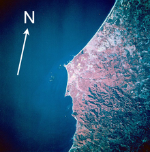
Barry’s uTube link to F/V Rosella being 24.342 nautical miles South from Cape Blanco. The cape, a relatively level landform with cliffs facing the sea, is about 200 feet (61 m) higher than the ocean. It consists of layers of uplifted marine sediments, ranging in age from 80 million years at the bottom to less than 500,000 years at the top. The uplift is continuing; Cape Blanco is rising by several millimeters each year. Generally, landforms on the north and south end of the Oregon Coast are rising as the ocean floor slides under the continent, while the central part of the coast “seems to be folding down.” Landforms near the cape include beaches, bluffs, and reefs. Visible to the south are Needle Rock, Blanco Reef, and Humbug Mountain. To the north are Gull Rock, Castle Rock, and Blacklock Point. Blanco Reef is a group of irregular rocks and ledges that are from 2 to 5 miles (3 to 8 km) offshore and are up to 149 feet (45 m) high. Too bad, I just found Barry’s Nautical Chart for the area here. Wonder how he is navigating these waters. I know he does not know how to read the stars. That’s what landlocked Captain Webb told me. Oregon’s salmon season starts April 1, 2015.
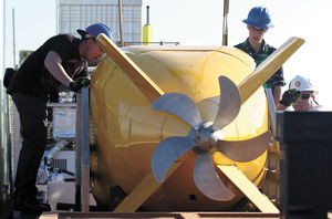
Mowing the lawn is what the minions of the Yellow Submarine called it. No, they are not members of Sergeant Peppers Lonely Heart Club band. This is the “Echo Ranger.” Captain Barry, F/V Rosella, was seen asking the operators if they would look for his last remaining missing crab pots lying on the ocean bottom (Aussies are notorious in not tying a proper crab pot nonslip mono loop knot). A group of onlookers watched along the Johnson Pier as engineers carefully prepped the cargo-container-sized sub for its voyage. The mini-sub, called an Echo Ranger, isn’t meant to ferry humans. The Boeing-built vessel was actually a robotic vehicle designed to take coordinates and be the eyes and ears for a team of government researchers working onshore. The plan is for the Echo Ranger to be loaded up on the Fulmar, a 67-foot research vessel run by the National Oceanic and Atmospheric Administration. In the coming days the boat and its crew plan to head out toward the Farallon Islands to use the robot sub to capture the best images to date of area shipwrecks. The mission is directed by the NOAA Maritime Heritage Program, a small team of archeologists and historians engaged in a two-year exploration of the local coastline. Last fall, the team conducted a five-day expedition to take a closer look at a graveyard of ships and steamers near the Farallones. This new excursion is focusing primarily on one vessel in particular, the USS Independence, a World War II aircraft carrier that was scuttled in 1951 that was nuclear bomb target. As the largest and deepest vessel lying on the sea floor, the Independence was seen as a good first run to test out the technology, said James Delgado, NOAA Maritime Heritage director. This is the first time NOAA researchers have worked with the Echo Ranger, which is provided free of charge by Boeing for the mission. They have other gizmos to try out too. The sub has been outfitted with a Coda Octopus Echoscope, a sonar scanner that can deliver high-quality 3-D images of the exterior of the ship. “It’s not unlike a sonogram to see what a baby looks like. We’re using the same technology in the deep ocean to see what lies there,” Delgado said. “There’s already some fishermen around the harbor asking if we can also find their pots.” The exploration is primarily archeological, Delgado said. The research team won’t be plumbing the interior of the Independence or trying to learn more about the nuclear waste that may be hidden with the vessel. Collecting images of the ship will be a slow process, which the team has come to call “mowing the lawn.” To get a good image, the robot sub will remain about 100 feet away from the ship and slowly survey it back and forth. The process will be extremely redundant to avoid gaps in the images, Delgado said. The exploration of the Independence is expected to continue over the next two weeks. Unlike previous shipwreck surveys, the Echo Ranger won’t have a tether linking it to the main research vessel. Instead, the NOAA team is trusting that the sub can safely pilot itself back to the larger research ship. The mission is directed by the NOAA Maritime Heritage Program, a small team of archeologists and historians engaged in a two-year exploration of the local coastline. Last fall, the team conducted a five-day expedition to take a closer look at a graveyard of 400 ships and steamers near the Farallones.
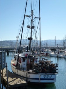
2015 Dungeness crab season on F/V Rosella was a super success! With an improved contact and order web component, we increased our customer base and orders a minimum of 40 folds or 868 crabs sold via the website. Weight: Over 2,000 pounds. Captain Barry’s crab pots have been hauled from the sea and stacked for the next season in the storage yard. Boat is being prep to chase salmon in Oregon and will embark to follow the salmon wherever they may be. Second Captain Maynor will be Second Captain. ETD is within a week.
In tonight, 250 pounds is Captain Barry’s final Dungeness crab load. Call and place your orders now!
Recent Comments